Pangboche to Namche Bazaar via Tengboche
April 16, 2011
Trip Day #18, Trek Day #12
It’s hard to describe what it’s like to awaken to sun streaming through the windows, warming up the room like some kind of California summer day, a dog sleeping at your front door and a pony in the yard. It was a glorious morning with eye-popping views of towering, snow-covered mountains against clear, deep blue skies.
Rick shot this one out his window.

The resident dog relocated to a sunny spot on the deck, and why not?

After tea and packing, we met in the very charming dining room and had fried eggs on toast and more toast with peanut butter and honey (well, that was my breakfast). And more steamy hot tea. We were all so happy and warm and loving life. Pangboche felt like heaven on earth.
The hike out was great, too. Here are Karen and Laura, setting out for the day. It’s still mid-April at 12,894 feet, and probably in the 30s this early morning, but sunshine and plants are making it feel tropical; note the lighter set of clothes:

We meandered through the outskirts of Pangboche, looking down the mountainside at green fields surrounded by stone walls, grazing animals, the river raging far below. Lots of flowers and trees.

Looking behind us, I finally got a clear, close-up shot of the iconic twin peaks of Ama Dablam:

We came upon this pack of animals, best guess: the Himalayan Tahr. (related to the wild goat). We scrambled around this slope and watched them eat and eventually, and skillfully, descend out of view:

We passed a mom and her child in colorful woolens:

And came upon a beautifully located stupa; looked back to see it dwarfed by Ama Dablam. Our trail is visible on the hillside, left of the stupa. Nice, huh?


Then we headed down to cross the river and climb the steep canyon wall on the other side, making our way to Tengboche Monastery. Here’s Leslie’s shot of the bridge far below. Note the water has that glacial run-off color:

And here’s where we’re headed on the other side… a couple of my favorite faraway shots of Tengboche. The setting is breathtaking, surrounded by views of Tawache (20,884), Thamsurku (21,675), Ama Dablam (22,493), Nuptse (25,801), Lhotse (27,940) and Everest (29,029). Tengboche sits on a hill 2000′ above the confluence of the Imja Khola and Dudh Kosi rivers (well, a Himalayan hill):


So, first down a thousand or two, then up a couple thousand. Pretty soon we hit a shaded trail. This was a very nice ascent, not an insignificant climb, but pleasant through the trees.

Here are a few other sights along the way to Tengboche Monastery. Here’s a farm Leslie shot:

Rick’s shot of grazing horses:

My favorite yak shot.

Passed homes, barns..

Passing people coming home from the Friday market… here are Leslie and Laura (note shirt sleeves; no down or soft shell parkas):

Nice packaging for the eggs.

Here’s a guy hauling sacks of grain, light enough, but unweildy:

It was just a beautiful day and the countryside was full of vegetation, life and color. We finally got to Tengboche.
Tengboche (also called Thyangboche) is a Tibetan Buddhist monastery. It isn’t a particularly old monastery, initially built in 1916, but its gompa was destroyed by an earthquake in 1939, rebuilt, and destroyed again in a fire in 1989. It was again rebuilt and reopened in 1993. It’s a sacred site for meditation & prayer, and at least one large annual festival.
Leslie got a shot of the grounds:

Monks are everywhere, in Patagonia down sweaters, no less:

Here are a few shots of the outside and inside of the gompa:


Then, time to head to Namche Bazaar! Here’s Karen (note mani stones):

The trail back down to the river, another 2000′, was very steep, brutal and unrelenting. But just beautiful. Surprisingly lovely to be in trees again. Leslie took this one of me:

Rick took this of a sherpa hauling a stack of boards up to Tengboche which also gives a sense of the terrain. You had to watch your step so carefully; the ground was packed and dense (usually), but embedded stones were trip hazards and kept you from really hauling out (as if your knees weren’t the limiting factor). Also, thank goodness for sticks.

The Rhododendrons were in full bloom at this elevation (approximately 11-12,000′) and views of Kantega (21,932′) were spectacular. Kantega means “horse saddle.”


After two miles and 2000 steep feet, we arrived at Phunki Tenga for a sunny, warm lunch at riverside. We were thrilled to run into Rie and Emily whom we’d last seen leaving Namche eight days earlier.

We heard stories of their misadventures: they’d all suffered some degree of altitude sickness, Rie had been evacuated by horse at one point in their journey, Emily was dealing with very impaired knees, and David had been treated for severe diarrhea in Pheriche. David was ultimately the only one to summit Island Peak and was a day behind them. Still, many smiles and many excellent stories to tell their Australian friends back home.
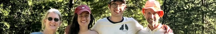
Here’s a nice group shot outside the restaurant: Karen, Laura, Leslie and me:

Rick had forgone lunch and taken off ahead in order to get to Namche in time to see the Saturday market, which he did and said it was interesting enough, though not what he’d expected.
After lunch, we crossed the river on a wood and stone bridge (the old one had washed out in the 2007 floods, the remains of which could still be seen) and headed once again up (and up and up) to the other side of the canyon. We passed charming villages like this..

..and, once far enough above the river, contoured and wended our way back to Namche on a very beautiful, relatively flat trail. Here’s one that Karen took:

And here are a couple that Leslie took (for sure that’s a huge drop, but the trail was wide and never felt too exposed):


I’d also separated early from the group and hiked alone for a while, then with Hom. We hiked quickly and I felt just great. I really enjoyed the views and conversation. It was fun, a few hours later, to finally reach the crossroads–the point where our group had gone north up to the Gokyo Lakes region eight days before, while other groups had continued northeast along the main EBC trail (which we were now on)–and retrace our way back into the hillside village of Namche.
Hom pointed out that there was a lot of traffic on the trail out of Namche and that most of the travelers were women carrying supplies purchased at the large, weekly Namche market (eggs, meat, household goods). Interesting to reflect on life in the car-less, mountainous Solo-Khumbu region of Nepal. Life’s pretty simple there.
In Kenjoma, about two miles outside of Namche, we saw a group huddled around a man who’d been seated just off trail and covered with blankets. Hom moved into the circle of people to assess the situation. The man looked to be in his 40s or 50s, fairly heavy, and just sat motionless, seeming lethargic and dull. Turns out, he was a Malaysian trekker, also in a Himalayan Glacier Trekking group, who was suffering from HACE (high altitude cerebral edema), which is very life threatening. His blood oxygen level was 60%! He was ultimately carried by sherpas and porters back to Namche and treated with oxygen. The next morning, Pradip and Homnath were among those who carried him to the heliport where he was evacuated by helicopter back to Kathmandu. He survived, we hear, but it was touch and go. In addition to the survival issues, he’d not obtained evacuation insurance, something that was absolutely required for this trek. We were all to have both the insurance and cash sufficient for the helicopter pilot in the event of an unplanned evacuation. I am not sure how financial matters resolved for this gentleman.
We rounded a broad corner and Namche finally came back into view. Wow, what a setting for a town. Impressed all over again by the vastness of the deep river canyons surrounding Namche and the sweeping panoramas that rise up and loom over the village. It is so incredibly dramatic and picturesque.

We meandered our way down, down, down and back to the Namche Hotel. The steep stone walkways and stairs seemed unkind to worn legs (and I wondered how that 3000 foot descent the next day was going to feel..) I took off to shop for souvenirs–mostly stuff for Peter, like a t-shirt with the route to EBC on it, a scarf of the seven summits (on seven continents), a singing bowl, a yak bell. I updated Facebook while sitting in a nearby sweet smelling bakery and took a shower (not as heavenly as I’d hoped due to a problem with the hot water heater). We all met for a celebratory dinner, joined by Rie and Emily, with lots of salty, spicy snacks and beer. So very, very, very perfect.
Rick had yak steak:

We again reflected on a great trip with no debilitating issues: no boot problems, no clothing failures, no altitude sickness, no achilles ruptures (me)… Again, it was all so smooth and enjoyable, challenging and rewarding. (And yeah, we were obsessed with these potential obstacles, so yeah, we celebrated, often, the fact we’d avoided them.)
And we were back in Namche, with showers and electric blankets. Fluffy hair, clean clothes and moisturized skin. And probably high on oxygen. What bitter cold? What penetrating wind? What rugged terrain? What thin air? It was all fantastic and immensely, deeply, satisfying. Here is a shot Karen took out our window of the full moon that night. Really, all of that AND a full moon on a crisp, clear night.

An incredibly beautiful, fabulous day. One day on the trail to go…
