
Phakding to Namche Bazaar
April 6, 2011
Trip Day #8, Trek Day #2
Already by day two, the rhythms and routines of the trip were established. Hom and Pradip were taking good care of us (and training us well). We’d made our tea selection the night before and at 6:30am, they brought it to our room on a tray. Have I mentioned how civilized and appreciated this was? Plus, a slug of piping hot, burn-your-mouth tea definitely took the edge off the frigid air.
We then had an hour to figure out what we were going to wear, what we were going to take in our backpacks, and what we were going to stuff back into our duffles for the porters to carry. We were to put our packed duffles outside our doors for the porters; they would meet us, with our bags, in Namche Bazaar later in the afternoon.
So cool.
Then, breakfast at 7:30, also pre-ordered the night before. I’d usually have oatmeal with lots of sugar and maybe a fried egg. Then, more tea, with lots of sugar (not usually my style). Upon reflection, I think I should have eaten a lot more protein. More eggs, maybe meat (when safe), peanut butter on the toast, protein bars along the trail… I think that may have gone a long way toward keeping leg muscles from getting as weary as they did. If you’re a person reading this and contemplating a long trek yourself, I’d recommend doing some research on diet, energy, muscle fatigue. I wish I’d been more savvy in this regard. It all worked out fine, but I think with a little thought about diet ahead of time, I would have felt much stronger.
We were on the road by 8 or 8:15. The torrential rains from the night before were gone. Funny mountain weather. We lined up on the deck outside our teahouse for a sunny pic (we would not do this everyday, don’t worry): Laura, Karen, Leslie, me, Rick. The things to notice here are: trees, clear skies, relatively light clothing. It might be in the high 30s or even low 40s here.

We’re also smiling because we haven’t gotten to the climb part yet. We gained about 2700′ that day over about 6.5 miles, not too bad, but with a very steep final stretch. For those who are given to measuring these sorts of things, it was like 1200’/mile steep. Ouch. Here’s how Lonely Planet describes the last couple miles:
“Grit your teeth and climb to a drooping suspension bridge at a dizzying height above the Dodh Kosi. There is a powerful sense that this is where the mountains really begin. From here to Namche Bazaar, it’s a torturous zigzagging ascent through dense pine forests and the climb will take you to an elevation where you may feel the first symptoms of altitude sickness.”
Here’s the profile for the day’s hike:

But, the day starts mellowly, as you can see, above, with mostly gradual ascents. The handful of very steep parts in the early going are relatively short, (though they don’t seem that short when you’re climbing them).
The walk through Phakding in the early morning was really charming.. shop owners sweeping, women washing clothes, pack animals getting loaded up, kids running around, the heavenly smell of incense, and I thought marijuana, but probably not. You could hear chanting through the open windows and doorways, and a variety of music. For some reason, reggae seems to be very popular in Nepal. Here’s a shot Rick took as we were leaving Phakding:

The hike continued through pastoral grazing land and farmland…


…through villages and past homes (and their residents) along the Dodh Kosi (which, in Nepalese, means milk river, by the way)..


Another of Rick’s shots:

…through lovely lower elevation country side (approx 9000′, a respectable Sierra elevation!) with magnolias, rododendrons and other trees in bloom…


…and over many a suspension bridge (about five this day). Here are some suspension bridge shots..
Things to notice about the bridges: 1) those in sacred locales have kata scarves and prayer flags tied to them, placed there for good karma; 2) modern bridges are made of steel and have massive cables to support them at either side of the canyons and/or rivers they cross; the older ones are made of wood, the remains of which can sometimes still be found near the new bridges; 3) they have cross bars about every 4 feet to keep people and animals from slipping too far; 4) they are really steep!, especially the long ones; walking back up after the low point can be a significant effort; 5) they are sometimes REALLY high above the water, making for very dramatic views; 6) pack animals handle them without issue, but it’s best not to try and pass an animal train… for obvious reasons; 7) they wobble and undulate and sway like crazy; 8) they are very fun to cross .


More bridge shots later.
Along the way we had a pit stop in a very attractive village called Benkar (on the way back, we’d have lunch here next to a modest waterfall) and got a clear and fantastic view of Thamserku (21,675′), one of the more premiere mountains in the region

We passed officially into the Sagarmatha National Park just beyond the village of Monjo.

We stopped here so that Hom could officially register our group and while he did that, we visited a tiny visitors center that included a huge model of the park and some other exhibits describing the region and its flora and fauna.
Sagarmatha National Park was founded in 1976 and was listed as a UNESCO World Heritage Site in 1979 (a program that recognizes and protects about 1000 sites (to date) around the world for their cultural or natural importance to humanity). It’s the highest national park in the world. Seventy percent of the park is above tree line (over 16,000′), rugged and steep, with terrain cut by rivers and glaciers. Three percent is forested, and the rest is grazing.
There are some rare species, including snow leopard, musk deer, Himalayan black bear and red panda, but we saw none. We did see some kind of pheasants and a bunch of birds that seemed unusual, but there were no birders in our group, so that was all lost on us.
Before our final ascent, we had lunch along the river, I think it was in a small village called Jorsalle. Typical lunch menu:

Following lunch, we ambled along the river for a while (just gorgeous!) then got to the famed Hillary suspension bridge, named, like so many things in this region, after Edmund Hillary. Here are some shots:

We were behind a mule train, so waited for them to get across. Those mules will have no trouble managing the very steep steps you see to the left of the bridge, below.

The wind blows hard in the river canyon (actually, this is the confluence of two rivers):

Here are a couple shots on the other side. The first is descending those steep steps.. right behind the mules. That’s the river far below.

This shot is looking back up at the bridge as we start down the steps.

But we now have to climb out of this river canyon to get to Namche which is on top of a mountain. It was two intense hours, steep and relentless. It was some of the most intense climbing of the trek, believe it or not, even though at a relatively low elevation. There were a lot of people and pack animals, too. Just about every trek in this region will pass this way, en route to Namche Bazaar, where park headquarters is (pictures later). I pulled up the rear for this stretch, not sure why. Karen was very spry and moved quickly up this hill. Awesome. Everyone else moved steadily. Me, too, albeit slowly, but that gave me some time with Pradip, our back end guy, who patiently kept my pace and sang. The singing was a lovely bonus.
Got to the Namche Bazaar gate and signed in (not sure what official business that was, but it was official).

Here were our first views of Namche Bazaar:
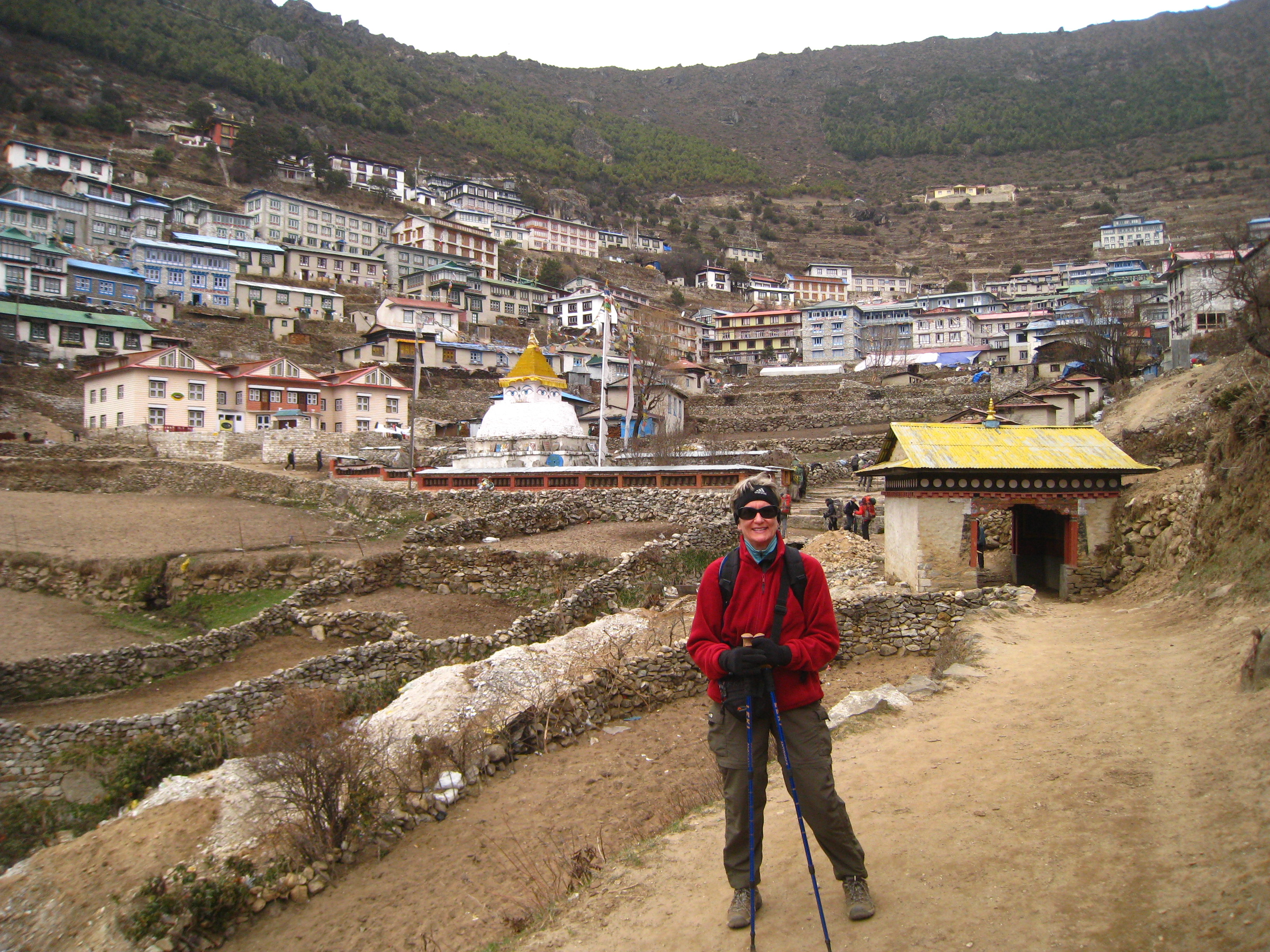

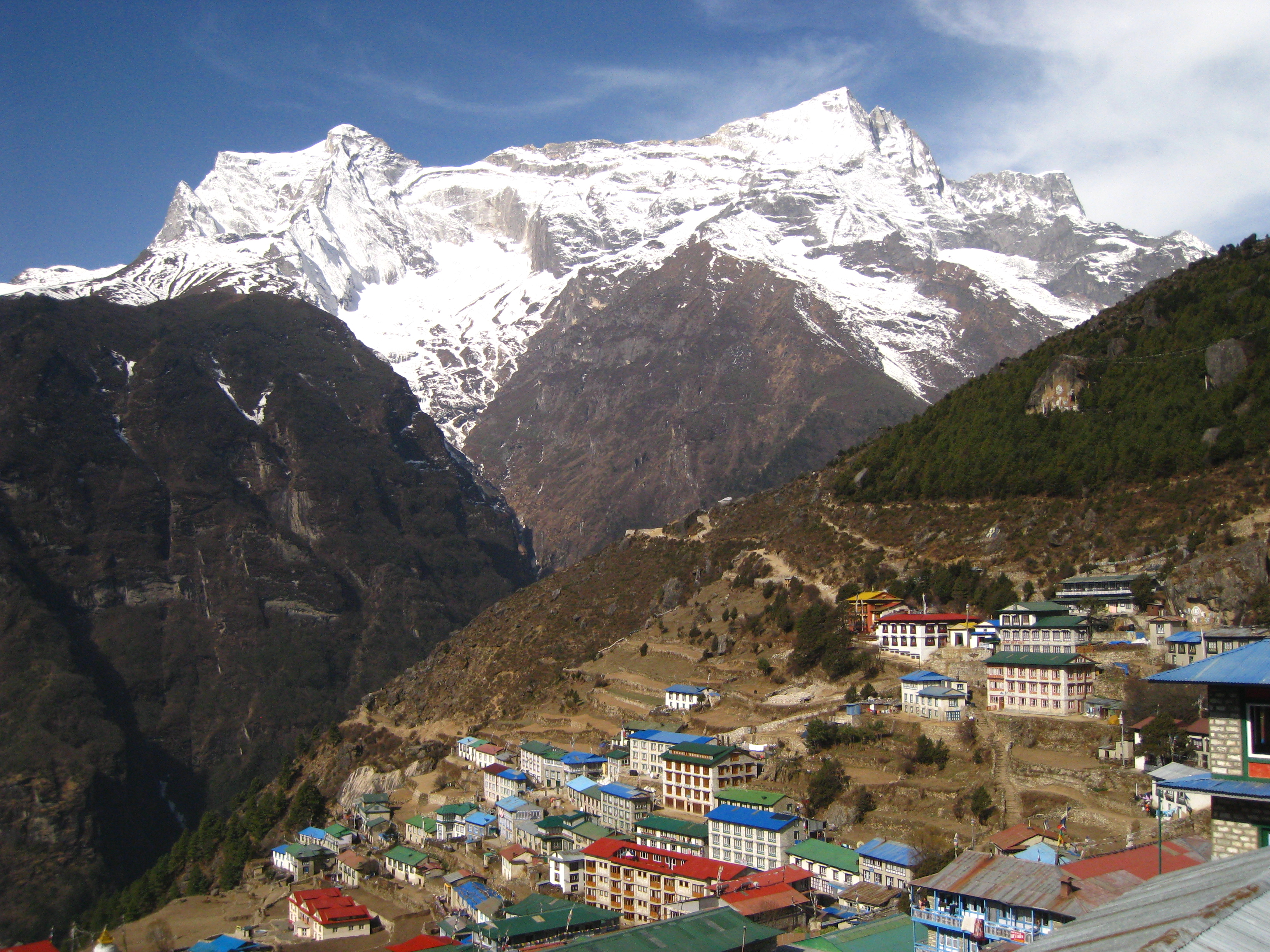
The town is built in the shape of an amphitheater and situated in a very steep bowl. We still had a lot of climbing to do to get to our hotel. While I didn’t get this shot until the next day, it’s worth looking at here to get a sense of the setting for Namche. It sits at 11,300′, high atop a mountain, a very steep climb out of two river valleys. But mountains also surround it. It’s breathtakingly beautiful.
When we crossed the Dodh Kosi river, on the Hillary suspension bridge, it was in the canyon at the bottom of all these mountains, far down and well below the view you see here. That dark green forested area that wraps around the hill is what we climbed up through to get to Namche.

Here are another couple of views of Namche from above (also taken the next day):

Inside Namche, it looks like this… a warren of narrow, cobbled streets, built on impossibly steep slopes. Animals, villagers, and lots of outdoor supply stores. It has a very international feel, due to trekkers from all over the world.


We finally got to our hotel, the Hotel Namche. A wonderful place. Entered through a hall that opens to a cozy dining room. To get to our rooms, we had to exit the main building, go down a set of stairs, turn left, and enter an adjacent four story building.

Here’s the dining room and lobby:

Here’s Karen’s and my fancy room (with its own bathroom, with western toilet no less, and hot shower!). The beds have electric blankets and huge, heavy comforters. We were so excited to be staying here for two nights.

Here’s the view from our place:

So, we got in, took hot showers, walked around a bit, did Internet, met for cookies and tea.
Then, for me, one of the most uncomfortable episodes of the trip happened. Way back at the Namche gate, I’d gotten a big whif of someone’s cigarette that gave me an instant headache.. it was manageable at first, but then intensified, and by dinner I was too nauseous to eat and went to bed in total pounding pain and angst over whether it was altitude sickness or just a cigarette headache and what I was going to do about it. I’d easily handled 14,500′ (Mt. Whitney, the summer before) so didn’t think 11,200′ was a problem, but I was a bit freaked out and wondered if I needed to take Diamox, which I really, really didn’t want to do. I compromised and took half a dose, and hoped I’d be better in the morning. I’ll talk more about altitude sickness in an upcoming post.
So that was the end of day two. Totally pooped, went to bed with a headache, but thrilled by what we’d experienced so far, thinking it was already way, way, way worth the price of admission.
